At around 550 kilometers in length, the Upper German-Rhaetian Limes is the largest and one of the best-known archaeological monuments in Germany. Since July 2005, it has been one of the 44 UNESCO World Heritage Sites in Germany and is one of the four World Heritage Sites in Hesse.
As a Roman statesman and general, Julius Caesar conquered Gaul between 58 and 51 BC, but Caesar failed to achieve a comprehensive administrative reorganization of Gaul. After campaigns by the stepsons of Emperor Augustus, Drusus and Tiberius, the region of Raetia was added in 15 BC. The borders of the Roman Empire thus lay along the Rhine and Danube. Augustus' ambition was to establish a pan-Germanic province that would extend as far as the Elbe. However, in the second half of the year 9 AD, the Roman legions lost against the Germanic army in the Teutoburg Forest in the so-called Varus Battle, which led to the abandonment of the plans for a pan-Germanic province extending to the Elbe.
In the 70s of the first century, Rome decided to shorten the borderline between the Rhine and the Danube, annexing fertile land such as the Wetterau. From the reign of Emperor Domitian (81-96 AD), the Romans began to build a border fortification known today as the Limes.
The border between the Roman Empire and the Germanic tribal associations was initially marked as a sentry way within a lane. In several stages, this border was increasingly fortified and the Upper German-Raetian Limes was created as a 550-kilometer-long complex, which was awarded "World Heritage Site" status in July 2005.
The section of the Roman border "Limes" that runs through GiessenerLand is part of the Upper Germanic Limes. The military and economic border fortification ran from Langgöns, Linden via Pohlheim and Lich to Hungen. There is evidence of 26 towers, ramparts and ditches, six small forts and castles in Lich-Arnsburg and Hungen-Inheiden along the 23.4-kilometre stretch of the Limes.
Evidence, traces and finds of this border fortification, which was abandoned in the 3rd century AD, can still be found in GiessenerLand today.
Arnsburg/Alteburg cohort fort
The Arnsburg/Alteburg stone fort for up to 500 soldiers was located in an exposed position on a plateau between the Arnsburg monastery and Lich-Muschenheim as the northernmost Roman cohort fort. It was built as a wood and earth fort in the early phase of the Limes. Archaeological investigations have documented other Roman facilities, such as restaurants, craft workshops, an amphitheater and a thermal bath.
Holzheim small fort
The small fort "Holzheimer Unterwald" was probably a road and customs station. It measured 18.60 meters x 19.40 meters. The entrance faced the Limes. Opposite was a culvert, with a paved path between the two. To the left and right were wooden barracks for 30 to 40 men.
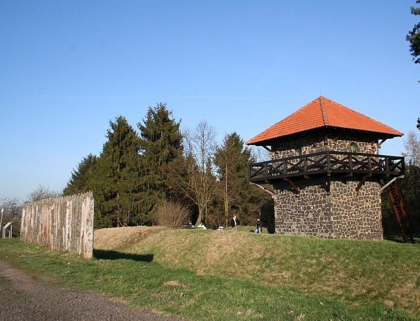
The watchtowers on the Limes
In GiessenerLand, 26 tower sites, connected by ramparts and ditches, have been identified along 23.4 kilometers of the Limes. The foundations of some of the towers (watchtowers) are still preserved in the ground. The watchtower Wp 4/56 on the Limes in Arnsburg Forest was rebuilt to a height of 65 centimetres in 2013. In Grüningen, a Roman watchtower and a section of the rampart and ditch with palisade have been rebuilt right next to the historical tower site Wp 4/49.
Collection of antiquities of the Justus Liebig University in the Oberhessisches Museum in Giessen
Coin collection, as well as a large number of antique vases, Greek and Roman terracottas, Roman glass vessels and Etruscan body part votives are among the focal points of the Giessen Collection of Classical Antiquities. The collection is housed in the Oberhessisches Museum in Giessen.
Limes posts on state and district roads and on federal highways
Limes is to be understood in its original meaning as path, aisle. The beginnings in our region are therefore in the aisles cut into the woods. In a later expansion phase, palisades were erected to reinforce them. Over the centuries, the ramparts and ditches of the aisles have only survived in sections and have disappeared completely where roads were built. Limes posts were erected in GiessenerLand to mark this.
Limes hiking trail section Wetterau
The Limes Cultural Trail runs from Rhineland-Palatinate and through Hesse and GiessenerLand to Bavaria, covering around 675 kilometers. The Wetterau section of the VHC is 91 km long and the stretch of the Limes Trail in GiessenerLand from Langgöns to Hungen-Steinheim is around 31 kilometers.
Limes circular trail at the Limes Information Center of the district of Giessen
At 3.2 kilometers, the regional Limes circular trail is an entertaining Roman nature trail with information boards and puzzle stations.
Muschenheim cultural and historical hiking trail
The hiking trail around Muschenheim takes in the Limes and other historical sites, such as Arnsburg Monastery. Read more...
German Limes Cycle Route
The German Limes Cycle Route connects numerous historical traces of the Romans along approx. 820 kilometers between the Rhine and the Danube.
There are numerous Sightseeing from Roman times to discover along the Limes Cycle Route between the Rhine and Danube. History-loving cyclists can look forward to reconstructed Limes watchtowers, fortifications with ramparts, ditches and palisades, preserved and partially reconstructed forts, ruins of Roman bathing facilities and impressive museums.
In GießenerLand, the German Limes Cycle Route leads from Butzbach through the municipalities of Langgöns, Linden, Pohlheim, Lich and Hungen, covering a distance of around 30 kilometers.
From 2009 to 2019, the Limes Cycle Route was expanded through a cooperation between the towns and municipalities of Butzbach, Langgöns, Linden, Pohlheim, Lich, Hungen, Münzenberg and Rockenberg.
The route of the Limes Cycle Path does not always run along the historical border line of the Limes, but also connects the towns near the Limes with each other.